|
|
 |
|
|
|
|
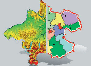
GIS - Geographisches Informationssystem
Stadtverwaltungen, Planungsteams, Geografen, Vermessungsämter, Statistiker brauchen es – das Geografische Informationssystem GIS, das weit mehr kann als präzise Karten erstellen. Mit GIS können statistische und geografische Daten kombiniert und anschaulich dargestellt werden.
Quelle: Ars Electronica Center
Verwendungsnachweis: Abdruck nur für Presse und nur mit Urhebervermerk honorarfrei!
 download
printversion download
printversion
back
|
|
|