Location-Based Storytelling
As a form of applied digital cartography, a WIKImap utilizes cutting-edge visualization techniques and interactive methods in order to endow the map with not only static imagery but also dynamic content and multiple layers of information having to do with urban life. The texts, images and sounds can be linked to a specific geographical location, and a Web interface allows them to be posted and thus made accessible to other users. This form of location-based storytelling leads to the creation of urban landscapes designed by the (permanent or transient) inhabitants themselves.
Community-like Virtual Information Landscapes
From this starting point, the Ars Electronica Futurelab developed the WIKImap Web application that makes it possible to weave elements of local culture—urban soundscapes, visualized metropolitan musings and text-based impressions of life in the big city—into the constructed urban realm. User-friendly software and interface design nurture the emergence of community-like virtual information landscapes that totally pervade the urban architecture and infrastructure, and become cells of socio-cultural (inter)activity.
Local Concept – Global Adaptability
Such interactive forms of digital cartography can be implemented anywhere in the world to foster new socio-cultural practices, to encourage people to take alternative approaches to establishing their presence in the public sphere, and to support them in going about this. The map becomes an information domain and an urban medium. Its liveliness and quality are determined by the active commitment and creativity of its users. The expansion of the map in the form of additional levels of information and interaction is a form of digital urbanity that is constantly being updated through its concrete local reference.
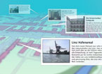
The WIKImap project was launched in conjunction with the Hotspot Linz initiative that will be setting up a citywide WLAN zone by 2008. The project concept and the software are already being translated into other geographical contexts and enhanced for other potential applications.
You can access WIKImap Linz, the interactive city map, at http://wikimap.hotspotlinz.at/de/intro.php.
| |
|
|
|
|
||