|
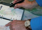
GeoCity is a futuristic presentation tool of an interactive urban- and geo-information system that provides interesting and unusual insights into the city and its functions. GeoCity has been conceived as a walk-through database that utilizes new means of communication to get across complex, interrelated information in an intuitive way. Whether it’s a book or a city map—everything morphs into an interactive surface. Analog and digital elements react to each other—pencil and paper unite with computer and projection.
GeoCity is based on the actual data of a chosen city that can be broken down into its various different functional levels. The system behind GeoCity is a Geographic Information System (GIS)
that works with aerial photographs of the city as well as a number of different sets of data which are melted together into a graphic user interface. The system functions in both online and simulation modes. Users can directly intervene in the simulated city and thus tinker at will with the network of streets, traffic light settings, park facilities, sewer system, and even the climate and other statistical data.
GeoCity Mobile is the pocket solution of GeoCity. Adding e.g. company or project specific data the mobile version serves as an innovative and surprising presentation tool to clients and business partners.
The GeoCity concept is transferable to any other city, region or place.
|