| SimLinz
1996
Gerhard Empl
Balint Hagedüs
Andreas Hopfner
Daniel Wagner
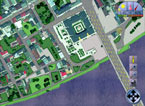
"SimLinz" is based on the actual data of the City of Linz, which can be broken down into its various different functional levels. Data from all municipal departments can be accessed on a Smartboard (an intelligent touchscreen).
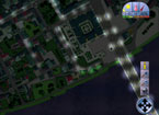
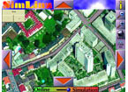
The system behind "SimLinz" is a Geographic Information System (GIS) that works with aerial photographs of the city as well as a number of different sets of data which are melted together into a graphic user interface. The system functions in both online and simulation modes. Users can directly intervene in the simulated city and thus tinker at will with the network of streets, traffic light settings, park facilities, sewer system, and even the climate and other statistical data.
Causes and Effects
Anyone can employ this easy-to-use system in order to redesign the city in accordance with his/her own personal tastes and preferences. Instituting changes to traffic light configurations makes it clear just how complex traffic planning is; routes can be closed off, whereby the effects upon the flow of traffic become immediately evident. It is also a simple matter to revise the overall climate and to observe the influences this brings about.
The city's various functional levels can be called up separately. The network of streets can be tuned out and replaced on-screen by the sewer system, for instance. The "SimLinz" database is being constantly updated and expanded.
|