| GIS—Geographic Information System
Data Spaces and Spatial Data
1996
Thomas Ebert
Kurt Pfleger
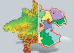
City administrators, planning teams, geographers, surveyors, and statisticians need it: the geographic information system GIS, which can do a great deal more than just generate extremely precise maps. With GIS, statistical and geographic data can be combined and graphically displayed.
Sensitive On-Screen Maps
At the terminals of the GIS installation, visitors can peel apart an interactive screen map of Upper Austria and focus on specific aspects. GIS displays transportation arteries, rivers and tributaries, administrative boundaries, as well as topographical models.
Processing Power for Planning
Images provided by DORIS, the digital Upper Austrian spatial information system, have proved to be a versatile, high-performance planning tool. For example, GIS was employed to develop the basis for the Austrian aircraft noise abatement law. To do this, a prognosis of the development of military and civilian aircraft noise pollution zones was produced, in which the noise data, real estate zoning provisions, demographic and building statistics, and municipal boundaries were interlinked and visualized. It was thus possible to compute the number of effected residents and the number of effected communities and buildings, as well as to generate a cost estimate for the implementation of noise abatement measures. Using GIS, this became a task that was easy to perform, and the results could be displayed in a way that was much easier to understand.
Related Projects
|
 SimLinz
|
|